TIME TRAVELLER – in conversation with Local Historian, Luan Hanratty

46 year old Tynemouth resident Luan Hanratty has strong Celtic roots. His father was born in Jarrow with their family connections going back to Galway in Ireland and his mother originally from Rosyth on the east coast of Scotland.

Luan at Arbeia Roman Fort, South Shields.

‘Yes, the Hanratty name is Irish, however, a brief background to my employment story is that I worked the financial sector in Prague, Czech Republic, moved to Shanghai in China where I was employed as an English teacher. I even appeared on TV there and published some books. Education is strong in my background as my father was a Drama Teacher’.

‘After Covid in 2020 I came back to the UK and based myself in South Shields. I was looking for my next adventure when I came across some local history and got obsessed with reading the stories’.

‘With my business partner Gary Holland we put together a website called Penbal – which is a Celtic name for the Tynemouth headland – the site features articles on Tyneside local history, photographs, AI art, links to Maritime Trust, Lifeboats Brigade and Fishermen’s Heritage plus local products for sale – prints, postcards, mugs, t-shirts and more’.

The latest story has recently featured on BBC News >>>

Roman Stones Missing from Mill Dam Roundabout, South Shields – Penbal

Luan’s latest post on the site is about a long lost river which flowed from the Mill Dam in South Shields.

‘Beneath the busy modern landscape of South Shields lies a forgotten natural feature – a river called the Mill Dam Creek but also known as the Branin River. This flowed from Mill Dam, next to Customs House today, out to the sea near North Marine Park and the Pier. This effectively made the Lawe an island’.

‘The channel played a vital role in the development of the town, both as a waterway and a habour, and once it was dammed with ballast, the Mill Dam formed a bridge between the north and south reaches of the early town’.

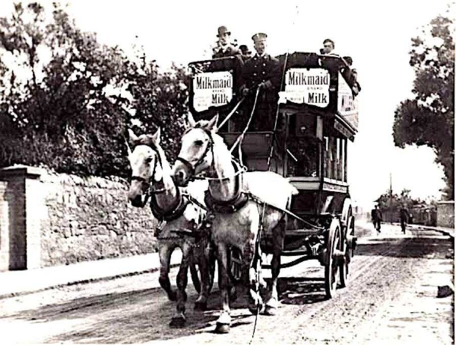
‘So important then, was the creek as a resource that it forms the base of the first industrial activity in South Shields, with coal mining also evident on the south bank where the pit wheel now stands above Asda carpark in Coronation Street’.

‘If you stand on the long sloping escalator when exiting Asda and look out across the huge carpark, you really get a feel for the valley nature of the Mill Dam Pond. Imagine what it must have looked like all those centuries ago’.

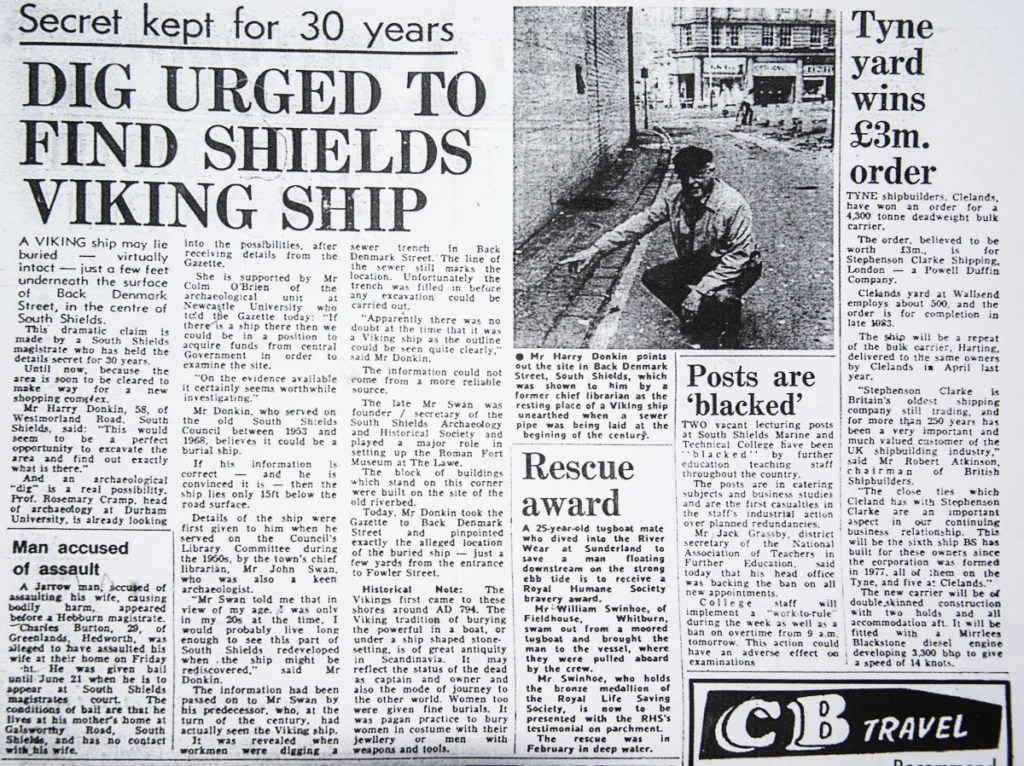
‘Another twist to the story is that in the 19th century much of the eastern end of the creek was covered by Denmark Street, where the Denmark Centre is today. In the 1830s, while building the street, a Viking longboat was discovered beside what was originally the river bed’.

‘Maybe there is someone out there who has more information about this amazing find. We know it featured in The Shields Gazette in the 1980s’.

Viking ship article in The Shields Gazette 1980s.

Full story >>> The Lost Waterway of South Shields:  Mill Dam Creek – Penbal

Luan stresses that he has no plans to research any murders or the race riots that have happened on Tyneside.

‘So far, we have over 200 local history posts and we don’t look at any taboo subjects, I just like to paint a picture of our very rich heritage here on Tyneside’.

For further information contact Luan >>>>

Penbal – Messis ab Altis

Alikivi   January 2025

FRAMING HISTORY

South Tyneside History website celebrates the heritage of the borough by preserving photographic and printed history. The images have been digitally recorded from original items held by South Tyneside library.

Included are historical maps, old postcards and thousands of images by notable South Shields photographers James Cleet, Amy Flagg and Freddie Mudditt – recently I’ve been invited to add my collection to the site so I’ll be in good company.

pic by Amy Flagg of South Shields Market bombed during Second World War. Courtesy of South Tyneside Council.

For over 25 years I’ve photographed South Tyneside, the main focus of this collection of images (2,000) were taken over the past decade of the changing face of South Shields.

The collection is a unique documentary record of the demolition of buildings at the sea front and market place, to construction of The Word, Littlehaven Promenade, Harton Quays, Haven Point and more – if it was getting knocked down or built up I was there!

Pic taken 11 March 2013 with South pier in the background and a flooded sea front car park, now the site of Littlehaven Promenade and Seawall.

The images will be available to view soon in the meantime why not check the site

 South Tyneside Libraries (southtynesidehistory.co.uk)

Gary Alikivi   January 2022

VILLAGE NEWS with Jean Stokes, author of a new book on Harton Village, South Shields, North East England.

What inspired you to write the book ?

I am a retired Art teacher and still live in Harton, where I was born and brought up. My father was born in Ferry Street in South Shields near the River Tyne, he took a great interest in the history of the town.

I followed in his footsteps and joined South Shields Local History Group, where I’m currently vice chair.

Harton Village 1900 was written for two reasons, firstly with the aim of raising money for St Peter’s Church in Harton and secondly to prove that Harton had been a village. Locally we hear quite a lot of other villages such as Westoe Village and Cleadon Village, but little is made of Harton Village.

My mam and dad always called the shops in Harton ‘the Village’ and someone new to the area thought that this phase was just an affectation, so I decided to prove it wasn’t.

I thought I would collect all the lovely, old, rural photos of Harton that I knew existed in the amazing archives at the South Tyneside Libraries and put them into one book.

They show just what Harton Village had been like at the beginning of the twentieth century when my parents were young and were brought on Sunday afternoon walks through the fields from South Shields town centre to enjoy the delights of the bow fronted sweet shop and the little aviary that then existed.

I believed lots of other people would be interested in discovering what the village had looked like and hoped therefore the book would make a profit which I could donate to the church.

I had a copy of the Godfrey Map of Harton from 1895, bought at the museum in Ocean Road, and knew there was a census in 1891, and another in 1901, and since the earliest photographs of the village were from the turn of the century, I decided upon 1900 as a good date to explore just who lived in the village and what happened there.  

I’m interested in maps and buildings but also people and their lives. However, unless you lived in a grand house or a pub, the 1891 census does not provide information about where this or that family lived. 


A photograph from about 1945, from the South Tyneside Libraries site showing an awning on the left which belonged to the Ship Inn off sales. The pedestrian is walking west along Marsden Road, nearly at the junction with Sunderland Road, by the smithy and the cottage where Jemima had lived, the one with the open door. The smithy and cottages were pulled down in 1964 to provide a car park.

Did you come across any unusual stories when researching?

Amazingly I found a hand drawn map of Harton Village dated 1896 among church documents, naming each family and where they lived. A truly amazing piece of luck.

With this, the census returns and the Godfrey Map I tried to bring the village to life with names and a little information about some of the individuals.  

A small example is that of widowed lady, Jemima Brown who in 1900, lived in one of the cottages next to the smithy, to the east of the Ship Inn. She was at that time the oldest inhabitant in the village.  

In 1902, when she was 89 the country celebrated the coronation of Edward VII and on Saturday 28th June Harton Village Council organised, as part of their coronation festivities, a drive for the old people of the parish in a horse drawn omnibus where she was given pride of place.

The bus was provided courtesy of the manager of the South Shields Tramways Company, Mr John Wilson, and drove from Harton to Marsden, along the coast to Whitburn, returning through the fields to Cleadon and back to Harton.  

One of the omnibuses that travelled to Harton from King Street in 1900. Photograph from South Tyneside Libraries. Most probably this was one of the two buses that took Mrs Brown and the other elderly village residents on their delightful trip.

What did you use for research ?

Along with the Godfrey Map of 1895, the church warden’s handwritten plan with notes and the census returns, I also had access to some scrapbooks of the period held in the church which contain cuttings from the Shields Gazette and other printed information.

On top of this I was also fortunate to be able to contact the descendants of some of the families I was writing about and obtain family photographs.  

The South Tyneside Library history site also provided some superb photographs.

What are you doing now & have you any projects planned for the future ?

I am busy working on a second book in what is to become a series on Harton, this will be called Harton Township 1921.

The idea for this came about during my earlier research as I began to appreciate that Harton was far more than just the village and in fact was a significant area that stretched to the east along the coast from Trow Rocks to Marsden and westward as far as Simonside.  

The area in the west, which included Harton Colliery, was taken into South Shields in 1901 but it was not until 1921 that Harton was completely subsumed into The County Borough of South Shields.

This second book will aim to tell the story of Harton Township from medieval times to 1921.  

I hope to have the new book ready for November 2021 to fully mark the anniversary of the end of rural Harton and the housing boom that covered the fields of the township.

Link to South Tyneside images: https://southtynesidehistory.co.uk/

Interview by Alikivi  April 2021.

AMY FLAGG WAR DIARIES #1 AIR RAIDS on SOUTH SHIELDS

In 2016 when researching in South Shields Library about Historian and Photographer Amy Flagg (1893-1965), along with her photographs of damage to the town by German air attacks during the Second World War, there was a number of personal scrapbooks full of the towns history and genealogy of families in the borough.

Also included was ‘Air Raids on South Shields’, the typed notes and diary entries were a record of official statistics of enemy attacks since the first bomb dropped in 1940.

The next few posts feature selected pages from Amy’s war diaries. Detail from Tyneside newspapers and maps have been added to some entries.

In one of the entries Amy recorded the night the war came to ‘Chapel House’, the Flagg family home in Westoe Village on Thursday, 16th April 1942:  

At 00.45 four bombs fell in the grounds of residential property in Westoe. The first on the edge of a field at ‘Seacroft’, failed to explode and was dealt with by the Bomb Disposal Squad.

The second and third fell in the gardens of ‘Fairfield’ and ‘Eastgarth’ respectively. The last one fell on the lawn 10 yards from ‘Chapel House’.

No casualties were reported but considerable damage was done to a large number of houses in the neighbourhood, including over 40 roofs of houses in Horsley Hill Road which were penetrated by lumps of clay thrown up by the explosions.

In her diaries Amy recorded incidents that happened on Tyneside, she would add accounts of what she had seen, descriptions of her photographs or what was in official Air Raid Precautions (ARP) reports.

Saturday 22nd June 1940: The first bombs dropped on South Shields were four high explosives dropped near the junction of Marsden Road and Centenary Avenue. Several houses were slightly damaged by shrapnel. There were no casualties.

Friday 9th August 1940: One high explosive bomb fell in a garden at the back of Lawe Road near Pearson Street. Four people in an Anderson shelter ten feet from the crater were uninjured. One Home Guard was killed by machine-gun fire. No casualties from the bomb.

Pic. Amy Flagg. Courtesy of South Tyneside Council.

A comprehensive report by Amy detailed a raid by German aircraft on Sunday 16th February 1941: 

This night will be long remembered in South Shields. 130 enemy aircraft were engaged in action on the coast from Hull to Berwick. Bombers and minelayers came over in waves and were met with intense Anti-Aircraft fire.

At 00.25 a Heinkel 111, was hit by gunfire and collided with a Barrage Balloon cable on the North Foreshore. Part of one wing was broken off and fell on the shore. The plane lost height very quickly and crashed in Beach Road.

One member of the crew bailed out but his parachute caught on the overhead wires and he hung downwards until rescued. He was badly injured and died shortly after admission to the Ingham Infirmary. The remainder of the crew perished with their plane on impact with the ground.

At 00.50 a mine, which had not been released from the bomb rack of the plane, exploded with terrific force. It was seen and heard from beyond Newcastle and windows were broken as far away as Tynemouth, North Shields, Westoe and Laygate.

The Model Yacht House in South Marine Park and a small building were completely wrecked. Parts of the plane, maps, papers and clothing were subsequently collected and dredged from the lake.

The explosion had tragic results – one officer of the Borough Police Force and one Auxiliary Fireman were killed. Two other members of the Auxiliary Fire Service died in hospital.

Seventeen more members of the Police Force, Fire Brigade and Auxiliary Fire Service were injured, some very gravely, and were admitted to the Ingham Infirmary.

Other enemy aircraft, apparently taking the flames as target, dropped bombs on Broderick Street, where an elderly couple lost their lives and several houses were demolished.

On the junction of Lawe Road and St Aidan’s Road, damage was caused to St Aidan’s church and a number of houses, ‘Sea Merge’ and ‘Tyne View’ being completely wrecked.

During the same raid six parachute mines descended on the South Sands near Trow Rocks, and on some fields near the New Marsden Inn, but caused no damage or casualties.

Many houses severely damaged and widespread breakage of windows was suffered in many parts of the town. 85 people were rendered homeless, some of whom were taken to an Emergency Centre.

Alikivi  April 2021

Link to Amy Flagg’s war photographs on the excellent South Tyneside History website.

https://southtynesidehistory.co.uk/

Link to Amy Flagg documentary ‘Westoe Rose’.

WESTOE ROSE – making the documentary about South Shields Historian & Photographer Amy Flagg | ALIKIVI (garyalikivi.com)

FAMILY PORTRAIT – Downey photography studios in South Shields & London

As I was sorting out some books this picture card fell out of one of them. It’s something I picked up at Shields Market a few years ago.

I’m not sure who the sitter is but the photo was taken by the Downey brothers, William and Daniel, who along with older brother James, had studios in the North East then moved to London.

Commercial photography was in it’s infancy when the brothers were taking pictures of royalty and personalities like Oscar Wilde.

Looking back to photographers in South Shields there was James Cleet with his housing clearance pictures during the 1930’s, and reported to be a bit of a showman in his mac and bowler hat, especially at Tyneside ship launches he would signify when he was finished by making a large sweep of his bowler hat and take a deep bow in front of the crowds.

Amy Flagg’s unforgettable Second World War images of a scarred town after the German bombs hit, then in her own darkroom printing photographs of devastating images of a town she loved, important pictures that still have a huge impact today.

Records show the Downey brothers worked out of a studio in London but before that were based in South Shields.

William Downey was born in King Street, South Shields in 1829, with help from his older brother James and together with brother Daniel, they set up a photographic business in the Market Square in 1860.

The studio became successful resulting in branches opening across the North East in Blyth, Morpeth and old Eldon Square in Newcastle.

In 1862 Queen Victoria commissioned William Downey to take a series of photographs illustrating the Hartley Colliery disaster near Blyth.

Soon after William and his brother Daniel moved to London where they accepted commissions from dignitaries and aristocracy including the UK royal family, the Emperor of Russia and King of Norway.

The brothers also took pictures of show business personalities from their studio at 57 & 61 Ebury Street in Belgravia, while older brother James with his grocery business, kept a studio open in South Shields.

Big brother James was a huge help to William and Daniel. He was a grocer and importer of German yeast with premises in West Holborn in 1865. Ten year later he had two shops trading as a grocer and confectioner out of 17 & 19 Eldon Street in the Laygate area of the town.

By 1881 he had one shop for his grocery business and opened the other as a photography studio. There is a record of a Frederick Downey at 19 Eldon Street, I suspect that he was James’ son who carried on the family photography business.

Meanwhile in London, Daniel and William continued their work of royal sittings and portraits. Sadly, Daniel passed away in Bethnal Green in 1881 while William died in Kensington in 1915. His son, William Edward, kept on the family business as did his son, Arthur.

A lasting record of their work is an impressive set of five books called ‘The Cabinet Gallery’ printed by Cassell & Company of London, Paris and Melbourne in 1890. The volumes include 36 photographs each plus a summary of the subject.

Kings, Queens, Professors and actors all sat for a Downey portrait, the attention to detail made them stand out among other photographers and ensured customers would return. Their stamp is on the back of some pages.

Throughout the early 1900’s there is records for a Downey photography studio at 17 & 19 Eldon Street, but unfortunately by 1912 the trail goes cold. What happened to the Downeys in London and South Shields? Is there more to their story? If you have any information to add please get in touch.

Source: Census records, Burgess Rolls, Wards Directories, Wikipedia, The Word South Shields.

Gary Alikivi   December 2019

HARD UP in HOLBORN – South Shields photographer James Henry Cleet 1876-1959.

During the 1930’s James Cleet was commissioned by South Shields Public Health Department to make a photographic record of ‘slum housing’ in the riverside area of the town – Holborn and Laygate.

Side Photographic Gallery in Newcastle produced a booklet in 1979 of some of the photos. Not sure if the term ‘slum’ was first used by Side Gallery or Public Health Department?

First time I came across James Cleet was when I was doing some family and history research in the Local History section of South Tyneside Library in 2007.

It gave me the idea to make a documentary highlighting Cleet’s work, and Holborn, the area once known as the industrial heartland of South Shields, plus the digitization project.

The Local History section had been awarded funding to digitize thousands of photographs they had in their archive and load them onto a new website. Volunteers were needed for this process and as I was self employed I could give a couple of hours a week to a worthwhile cause.

Spending time looking through photographs, some from the early 1900’s, of people, places and events around South Tyneside was a great way to spend a couple of hours.

It wasn’t long till I dropped in more frequently. Photographs by Emmett, Flagg and Cleet were an excellent record of the times.

Some images had familiar street names of area’s where my ancestors lived, mainly Tyne Dock, Holborn and Jarrow. Finding a family of photographers called Downey who had a studio in Eldon Street next door to where my great grandmother lived was an added bonus.

There was a small team of volunteers who recorded details of the images, scanned the photos, and uploaded them onto the website, this process features in the documentary.

Street names, buildings, shops and people were researched, as much information as possible was added. On the back of the pictures was nearly always a date or name of the photographer.

But unfortunately, some photographs were left blank and didn’t have any recognizable signs but were still uploaded.

After a few sessions I could recognize the styles of certain photographers and two of them stood out. Amy Flagg added extensive details to a lot of her work and covered some powerful subjects like the Second World War – climbing over bombed houses to get the shot won’t have been easy.

Some of her images became instantly recognisable, in her darkroom she stamped a date in Roman numerals on the bottom of the photo.

There were a load of photographs that were taken in Holborn by James Cleet, his style and composition was of a very high quality with clean, sharp images. Most of the images are taken on overcast, grey rainy days – is that a coincidence ? I doubt it.

The lighting gives the pictures a uniform look and add to the bleak, grim atmosphere of the housing clearance.

In research I found Cleet had regular work at ship launches, plus The Shields Gazette and Daily Mirror. While Flagg’s technique was more handheld, Cleet used a tripod in most if not all of his very sharp pictures. Both were passionate about their work.

Around that time an old guy used to come to the local history section and tell me a few stories about Tyne Dock and Holborn as his family lived in those areas.

Next time he brought in a booklet which he gave to me, it featured a collection of the Cleet housing clearance photographs I’d been looking at.

The booklet also included reports by the South Shields Medical Officer for Health talking about ‘rat repression’ and ‘eradication of bed bugs’. They reported….

’The women had a very hard life. They polished their steps, and the pavement was scrubbed. The backyard was washed regular. There was a question of pride. They had to keep them clean or they’d be overrun with vermin. No getting away with it. It had to be kept down’.

The report also included complaints from residents…

’A’ve seen some hard up times. Families of nine in one room. I knew a family, the father and mother had to gan ootside to do their business. Yes they used to do their courtin’ ootside. The mother used to stand at the telegraph pole on Johnsons Hill and have her love with the husband and then gan yem to bed. You couldn’t do nowt with all the family livin’ in one room’.

In a previous post I wrote about the important historical archive that Amy Flagg had left to the town: her Second World War photo’s plus the book ‘The History of Shipbuilding in South Shields’, the James Cleet housing clearance booklet is just as important a document of South Shields.

To check out the South Tyneside photographs featuring Amy Flagg and James Cleet go to :   https://www.southtynesidehistory.co.uk/

Gary Alikivi   December 2019.

THE VILLAGE PEOPLE – new local history book about Westoe, South Shields by Dorothy Fleet.

In 2016 I made a documentary ‘Westoe Rose’ about South Shields photographer and local historian Amy Flagg who lived in the Westoe area of the town.

Her most notable work was recording the impact of bomb damage on South Shields during the Second World War. When doing some local history research in The Word I came across a new book about Westoe.

The book goes into great detail not only of the houses but it’s residents. The section on Chapel House, where the Flagg family lived, includes a copy of an inventory of furniture which Amy listed for 21st May 1941.

It includes a typewriter and photographic equipment in an attic, a what not and stirrup pump in the hall, with a gongstand in the breakfast room – it’s all in the detail.

To find out more I talked to the book’s author and member of South Shields Local History group, Dorothy Fleet…. 

More recently the Village has undergone a revival and many houses have been restored as cherished family homes. It has regained its elegance and has a sense of the atmosphere of yesteryear. Although it is now totally surrounded by our busy town, Westoe Village remains a place apart.

This book tells the story of each of the houses and the families who lived there from the mid-1700s. About 200 years ago it gradually became the desired location for families of successful local businessmen, who often worked together for the successful development of the town. For centuries before then it was a remote rural village of farms and cottages.

(Map of 1768 with the River Tyne flowing out into the German Ocean, now the North Sea. A blue arrow points to Westoe at the bottom of the pic).

One of the stories in my book about the history and notable residents of the Village concerns Mrs Paine and her family. In 1780 a dashing Royal Navy Lieutenant called William Fox was in command of the ‘Speedwell’, an armed vessel on press gang duty in Peggy’s Hole on the North Shields bank of the River Tyne.

Mrs Paine’s young daughter, Catherine, fell in love with William and they arranged to elope to Gretna Green. Catherine joined William in a horse drawn carriage and they travelled at speed, changing horses at the posting stations along the way.

Married by the blacksmith at Gretna, they returned home the following day, and their marriage was accepted by the family. The following year Catherine gave birth to their son, George Townsend Fox.

Their romantic story ended tragically when William fell or was pushed into the icy cold river late one night when boarding the ‘Speedwell’. His fellow crew members recovered his body but, with no knowledge of hypothermia, presumed he was dead.

Left almost penniless Catherine returned to her family home. By 1807 her son George Townsend had married and had eight children, one was William who emigrated to New Zealand.

After a highly successful legal and political career there, he served four terms as their Prime Minister and his childhood home in the Village is now a privately run hotel that bears his name.

The book is already selling well and with all proceeds going to the Local History Group to hopefully keep the group going forward and remaining solvent. With all the research, design and illustrations it’s been a real team effort.

For further information about ‘Westoe, a History of the Village and it’s Residents’

contact:   dorothyfleet60@gmail.com  

Interview by Gary Alikivi   November 2019.